Busan Regional Office of Oceans & Fisheries
Port Information
Busan Port
Port of Busan is a pan-Pacific hub port leading the 21st century
Located at the southeast end of the Korean peninsula, Busan Port is Korea’s number one port, acting as a gateway to connect the Pacific and the Asian continent, and is responsible for 34% sea freight exports, 75% of container cargo, and handles 13% of marine goods produced in Korea. The port is subdivided into North Port, Gamcheon Port, New Port, and Dadaepo Port.
Geographical Conditions and Status
Busan Port is located at the southeast end of the Korean peninsula (35° 04′ 42" N, 129° 01′ 01" E) acting as a gateway connecting the Pacific and the Eurasian continent, and it is Korea’s number one port and the world’s number six container cargo port. It is surrounded by mountains and islands which is the reason the port is renowned for its calm sea surfaces and low tidal changes, and it is located near the world’s three largest trunk routes creating the perfect port conditions.
Development Status of Port Facilities
Busan Port first opened in the name of “Busanpo” in 1876, commenced its first dock construction in 1906, and has since developed into a modernized port consisting of a total of 4 ports (North Port, Gamcheon Port, New Port, and Dadaepo Port), and 9 container terminals and international passenger terminals.
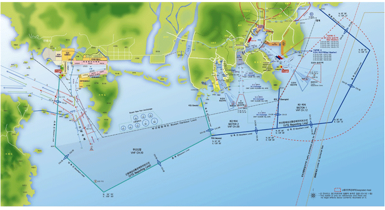
Port Limits
The port limits consists of the following sea area starting from the southernmost end of Shinmyung Myungdong of Jinhae-gu, and stretching to the southeast end of Udo, southwest end of Yeondo, southern end of Gadeokdo (34° 59′ N, 128° 49.5′ E), southern end of Saengdo, southern end of Oryukdo, point of 35° 08′ 33.20" N, 129° 08′ 51.60" E, southern end of bypass of the southern part of the Gwangan Bridge (35° 08′ 08.90" N, 129° 06′ 53.20" E), and the endpoint of landmass (35° 08′ 06.00" N, 129° 06′ 44.00" E).
| Water Area | Tidal Changes | Length of Coastline | Water Depth |
|---|---|---|---|
| 229,000㎢ | 1.3m | 202㎞ | (-)5m ~ (-)15m |
- Busan Regional Office of Oceans & Fisheries 351, Chungjang-daero, Dong-gu, Busan Tel:82-51-609-6114 / Fax: 82-51-609-6219 Copyright (c) 2016 Busan Regional Office of Oceans and Fisheries All Rights Reserved